hiking in forest of compiègne
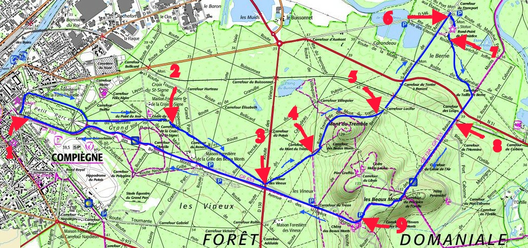
The hike begins at the Chateau of Compiegne. For a distance of about 15 km and 4 hours. You have a parking lot between the racecourse and castle, use the input panel to enter the park (No. 1 on the map). Upon entering the park, follow the left to go to the castle, then continue on the left the ascent of the park until the exit and you will have afar, a view of the castle.
Pass the gates of the park and pledge to left on avenue du Berceau, then pass the crossroads of Point du Jour and continue straight for about 200 meters before turning on the right towards the crossroads du Renard by a forest road (No. 2 on the map). Continue past the crossroads du Renard to the road D 130.
Cross the road D 130 (No. 3 on the map) and veer off left towards the crossroads of Mont du Tremble.
At the crossroads of the Mont du Tremble (No. 4 on the map) continue straight and after 50 meters take the left turning drive from Mont du Tremble. Halfway this rotating road, take the path that gently slopes down to the left towards the crossroads of Lucifer (No. 5 on the map).
At the crossroads of Lucifer, turn left and descend to cross the railroad tracks, then cross the national 31 (Look out ! ). Follow just in front the road, which leads you far as the crossroads of the Armistice (No. 6 on the map).
You can discover the famous wagon of Marshal Foch where the armistice was signed.
To start, take the track located at the end of the parking lot of the Armistice clearing in the direction of the crossroads of the Wolves (No. 7 on the map).
At the crossroads of the Wolves, cross the National 31, then cross the tracks and then at the fork, left the main road to keep straight the path up (No. 8 on the map).
Continue through the zigzag path and reach the plateau des Beaux-Monts.
Before the descent, follow the way on the right to go to the parking des Beaux-Monts top of the esplanade (No. 9 on the map).
From the esplanade, take the path down. You will then go straight to the castle, by successively cutting departmental 130 and you spend the grid des Beaux-Monts.
